Jaw-Dropping Photos Reveal What Hurricane Laura Looks Like from Space
On earth, Hurricane Laura is one of the most dangerous and destructive forces of nature we’ve seen in some time. In fact, the Category 4 storm system is the biggest the region has seen in a century, and it poses a major threat to several southern and mid-south states as it heads northeast across the country delivering high-powered winds, torrential rain, and possible tornadoes. So far, thousands of Gulf Coast residents are already without power since the hurricane made landfall at 1am on Thursday.
From space, however, Hurricane Laura appears as something else entirely: a quietly imposing cloud formation that is nothing short of jaw-dropping to behold. Yesterday, NASA astronaut and Chris Cassidy posted these utterly stunning images of the storm from the International Space Station:
Views of Hurricane Laura taken from @Space_Station today. Stay safe everyone. pic.twitter.com/KwVvRLA15m
— Chris Cassidy (@Astro_SEAL) August 26, 2020
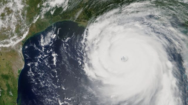
Yes, that’s a picture of a hurricane that is tied for the windiest storm in the history of Louisiana—and one that’s even bigger than 2005’s Hurricane Katrina. But NASA astronauts aren’t the only ones with an aerial view of Hurricane Laura. The National Oceanic and Atmospheric Administration (NOAA) revealed these stunning images and videos, as well:
Since the #GOESEast 🛰️ watched #HurricaneLaura make landfall at 1 a.m. EDT as a Category-4 storm, #Laura has become a Category-2 as it is moves over land. Damaging winds and widespread flash flooding are expected to continue.
Stay up-to-date: https://t.co/1L8q1zg4eW pic.twitter.com/B4xPOzQSSf
— NOAA Satellites (@NOAASatellites) August 27, 2020
For this #WednesdayMorning, take a look at #HurricaneLaura with @NOAA‘s #GOESEast satellite as the hurricane’s convection bursts with lightning. As of 8 a.m. EDT, #Laura had winds of 115 mph and was rapidly intensifying in the Gulf of Mexico.
Latest: https://t.co/1L8q1zg4eW pic.twitter.com/yyxJkmlfnj
— NOAA Satellites (@NOAASatellites) August 26, 2020
The folks at the Weather Channel contributed these:
Hurricane Laura’s Rapid Intensification in Satellite Images: Cat 1 to Cat 4 in 24 Hours | The Weather Channel https://t.co/ctJWzdDgcu
— thom reedy (@thomante) August 27, 2020
Atmospheric scientist at the University of Albany, SUNY, Philippe Papin offered this stunning video:
It has been quite something watching #Hurricane #Laura traverse the Gulf of Mexico the last 54h from #Cuba to #Louisiana.
In that time, winds dramatically increased from 55 kt–>130 kt & the satellite presentation went from ragged due to N shear into a textbook major hurricane. pic.twitter.com/AIKj0FE8rt
— Philippe Papin (@pppapin) August 27, 2020
And a Canadian-based Twitter account who is a weather enthusiast posted the following from NOAA.
#HurricaneLaura2020 moments ago from #NOAA 19 #Weather #satellite #HRPT Image 2020-08-27 12:37:19UTC #Hurricane #SDR
fullres: https://t.co/PEcNXQYOnR pic.twitter.com/g0FToRib66— Quarta’s Reef (@QuartasReef) August 27, 2020
Since making landfall, Hurricane Laura’s winds have been reduced to 85 mph, but there has been at least one death recorded so far, while upwards of 500,000 residents of Louisiana—and more than 125,000 in Texas—are already without power. We can only hope that everyone stays as safe as possible. And to learn more about these harrowing natural phenomena, be sure to read these 18 Hurricane Facts to Put You in Awe of Mother Nature.