8 Regions With “Troubling” Hurricane Conditions This Week
Knock on wood, but so far this year, hurricane season has been on the down-low. Yesterday, Sept. 10, marked the official halfway point of hurricane season. (To refresh: Hurricane season runs from June through November, with storm activity peaking from September onward.)
It’s the first climatological peak without a named storm in the Atlantic basin since 2016, according to an AccuWeather report shared with Best Life. Moreover, it’s the first time in over 30 years that there wasn’t a named storm over Labor Day weekend. And Northern Hemisphere tropical cyclone activity is down 60 percent so far this year.
“This will likely be the first time in nearly a decade that the peak of hurricane season passes without a named storm. This rare occurrence has only happened three times in the last 30 years,” says AccuWeather Lead Hurricane Expert Alex DaSilva. Apart from 2016, this trend occurred in 2014 and 2000.
But while Mother Nature has brought an “exceptionally quiet stretch during the typical peak weeks of the Atlantic hurricane season,” AccuWeather meteorologists say it’s just the calm before the storm.
RELATED: 4 Regions Where Hurricane Season Will Be the Worst This Year.
“This is the time of year when water temperatures in the Atlantic typically peak, and atmospheric conditions are most conducive for tropical development. The frequency of storms in the Atlantic basin is highest on average on Sept. 10, according to historical data,” explains DaSilva.
In other words, hurricane conditions are expected to be in full force starting this week.
“AccuWeather predicted in March, when we issued our hurricane season forecast, that surges of dry air could lead to a midseason lull,” continues DaSilva. “We have been forecasting the second half of the season to be more active than the first.”
As Best Life reported earlier this month: “AccuWeather is forecasting 13 to 18 named storms, of which 7 to 10 will be upgraded to hurricanes. It’s estimated that 3 to 5 will be classified as ‘major’ hurricanes, and 3 to 6 will make a direct impact on the U.S.”
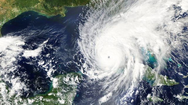
Heading into the latter half of hurricane season, meteorologists warn that “troubling” conditions are on the horizon. Specifically, they’re observing reductions in dry air, Saharan dust, and disruptive wind shear. So far this month, dust from the Sahara has fallen below typical range and average levels.
Surges in sea surface temperatures and ocean heat content in the Gulf (the amount of thermal energy trapped in the ocean) are also at “record territory for this time of year.”
“This exceptional warmth in the Gulf is troubling. The warm waters can act as fuel for developing tropical storms and strengthening hurricanes,” explains DaSilva.
He warns, “Atmospheric conditions are forecast to be conducive for tropical development in late September. We are concerned about the risk of rapid intensification if a storm forms or moves into the very warm waters of the Gulf later this month. Conditions are primed for explosive, rapid intensification.”
RELATED: 34 States That Will Have Unusually Hot Falls This Year.
As for which regions will get hit the hardest, the Southwest Atlantic, Gulf Coast, and Caribbean are on high alert. Meanwhile, landlocked states should brace for potential flash floods, as Best Life previously reported.
AccuWeather’s latest report highlights eight states and territories that are at a “higher-than-average risk” of direct impact this hurricane season:
- Texas
- Louisiana
- Mississippi
- Florida Gulf Coast
- North Carolina
- Atlantic Canada
- Puerto Rico
- U.S. Virgin Islands
Additionally, experts warn there’s an “increased risk of tornadoes and flooding from tropical storms and hurricanes reaching farther inland this year.”