Late Winter Storm Could Bring Another 6 Inches of Snow to These Regions
An early blast of unseasonably warm weather last weekend may have led some people to assume that spring had arrived ahead of schedule. But for some areas, there might be a few remaining bits of winter on the horizon—including some of the white stuff and chillier temperatures. That’s because a late winter storm could bring as much as six inches of snow to some areas of the country after an already wet week. Read on to see which regions might see some fresh powder this weekend and if you’ll be affected.
RELATED: New Forecast Predicts Very Active Hurricane Season—How It Will Affect You.
The East Coast has been drenched with consecutive rainy days this week.

After a quick blast of warmth over the weekend, wet weather has brought many parts of the East Coast back to reality. A wave of back-to-back storms drenched the Northeast, dropping two to three inches on the region, Fox Weather reports.
The downpours also led to flash flood warnings, including in cities such as Boston, Philadelphia, and New York City. The first system pushed in from the Midwest, where it was expected to produce outbreaks of severe weather and flooding, while the second brought heavy moisture from the South.
But while the current system is expected to push out by the end of today, there’s more in store for the area.
RELATED: “Remarkable” Polar Vortex Disruptions Could Send Temps Plummeting Again—Here’s When.
A new system is expected to push through the Northeast this weekend.

Residents in the Northeast won’t have very much time to dry out before more moisture pulls in behind it. After a short break on Friday, another bout of wet weather is expected as two storm systems converge, bringing a mix of snow and rain to the region once again, AccuWeather predicts.
The first system is expected to bring warmer coastal air into the Appalachian Mountains. There, it will combine with moisture moving up from the Gulf, producing precipitation in an area ranging from southern Illinois and Tennessee to Michigan through upstate New York and down to North Carolina. Some forecasts say it might even produce some severe weather.
“Drenching rain may be accompanied by thunderstorms that can advance northeastward from the mid-Atlantic into southern New England, raising concerns for urban and small stream flooding and leading rises along some area rivers,” said Joseph Bauer, a meteorologist with AccuWeather.
RELATED: Live in These 10 Places? You’re Most at Risk for “Extreme Winter Weather.”
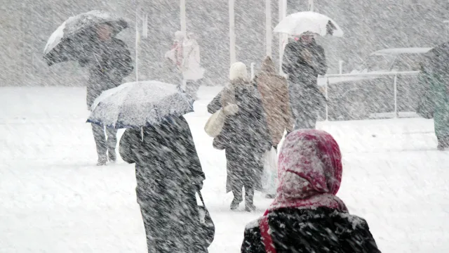
Snow is expected to fall in other parts of the Northeast as the storm progresses.

By late Saturday night, parts of the Northeast could see raindrops transition into snowflakes.
“As the two storms combine, the injection of colder air will trigger a change to wet snow or snow showers over the central and northern Appalachians from Saturday night to Sunday morning and then even some bands of lake-effect snow around the eastern Great Lakes on Sunday,” Bauer said in a forecast.
Predictions put higher elevations in New York, Vermont, New Hampshire, and Maine in line to receive six or more inches of snow through Sunday, Fox Weather reports. Parts of upstate New York and western Pennsylvania could also get a slight coating or up to two inches, while cities such as Boston, Providence, and Hartford might also see a few flakes.
Areas further south along the coast will still see rain that could linger through Monday morning, with up to an inch falling in total, per Fox Weather.
Chilly temperatures will kick off next week once the storms subside.

Depending on your weekend plans, the incoming storm might be a boon—especially if you’re hitting the slopes.
“Up to several inches of wet snow may accumulate on grassy areas over the ridges during the weekend’s second half, mainly over the Adirondack, Green, and White Mountains,” AccuWeather meteorologist Brett Anderson said. “That snow may provide a boost to ski resorts in the region following a week where a significant thaw has occurred.”
If the snowfall weren’t enough, much of the East Coast will get another reminder it’s still winter when the temperature drops in the wake of the storm. From late Sunday through Monday, gusty winds reaching up to 50 miles per hour will cool down the region, with inland parts of the Northeast sinking into the single digits and coastal areas plunging to the 20s and 30s, AccuWeather predicts.
However, the late winter storm won’t force residents to suffer for too long. Forecasts expect temperatures to rebound relatively quickly, stabilizing to normal by midweek.