Severe Weather Will Bring Tornadoes, Large Hail to These Regions: “Stay Close to Home”

Though summer and early fall can bring devastating weather due to hurricane season, destructive storms are possible in other parts of the year, too. The transition from winter can also be a dangerous time for severe conditions in many parts of the U.S., where high winds and heavy precipitation can create hazardous situations. And this week, meteorologists are warning that a wave of severe weather will likely bring tornadoes and large hail to some places. Read on to see which regions could see extreme storms and what conditions will look like heading into the weekend.
RELATED: 2024 Hurricane Season May Be 170% More Active—The States Most at Risk.
Severe weather is moving across the Southeast today through tonight and tomorrow morning.
Spring appears to be keeping its reputation for its roller coaster weather. Today, parts of the Southeast are at high risk for severe storms through tonight or tomorrow morning, Fox Weather reports.
The Gulf States currently face the greatest potential threat. Parts of Louisiana, Alabama, and Mississippi have been designated a Level 4 out of 5 on the severe weather risk scale, according to the National Oceanic and Atmospheric Administration’s (NOAA) Storm Prediction Center (SPC). However, an area that includes much of Arkansas, Tennessee, central Georgia, and the Florida Panhandle also still faces a “possible” to “likely” threat, per Fox Weather.
The storm may already have spawned one tornado earlier today in Katy, Texas, where the National Weather Service (NWS) was trying to determine the cause of concentrated damage. Now, some schools and universities have canceled classes in Louisiana as the dangerous system makes its way east.
“There are a lot of threats,” Britta Merwin, a meteorologist with Fox Weather, said during an update. “You want to stay close to home.”
RELATED: Widespread Blackouts Predicted for 2024—Will They Hit Your Region?
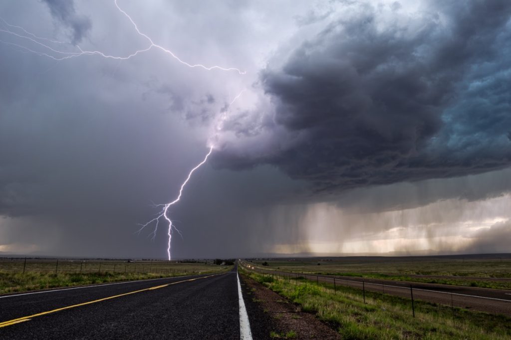
The storms could spawn “double-digit” tornadoes and produce massive hail.

Forecasts warn that the storms could generate large hail, with parts of Texas reporting “ice the size of teacups” falling earlier this week, AccuWeather reports. And for the rest of today and early tomorrow in some places, an advancing cold front could bring damaging winds of up to 80 mph and the potential for devastating tornadoes.
In fact, some are warning there could be a significant safety threat through this evening.
“We believe there will be double-digit tornadoes produced by the severe weather outbreak, and multiple tornadoes could be on the ground at the same time on Wednesday despite less-than-perfect atmospheric conditions,” Bernie Rayno, AccuWeather chief meteorologist, said during a forecast.
RELATED: New Spring Forecast Shows Which U.S. Regions Will Be Warmer and Wetter This Year.
The system will continue to push east tomorrow and bring severe weather to other regions.

Devastating weather may continue through the rest of the week. Forecasts show the front will continue its advance east tomorrow, bringing the storms closer to the coast, Fox Weather reports.
According to forecasts, the Southeast, Mid-Atlantic, and Northeast are likely to catch the brunt of the severe weather through Thursday. The swath of potentially affected areas runs from western Pennsylvania and Ohio down to Southern Florida, and from West Virginia to the coast.
The places most likely to be affected include Ohio, western Pennsylvania, southeastern Georgia, and northern and central Florida, per Fox Weather. Besides torrential rain, the storms could also pack damaging winds of up to 60 mph and large “quarter-sized” hail.
Dangerous flooding is also likely to be an issue throughout the region.

After the threat of tornadoes passes, many areas will have to deal with another issue. Heavy rain will also hit the region, bringing as many as two to eight inches to the Southeast and Gulf through Thursday, AccuWeather reports. One area covering southern Arkansas and northern Louisiana could even see up to eight to 12 inches of rainfall.
“The amount of rain forecast to fall is equal to or greater than an entire month’s worth and will pour down in just three to four days,” Tyler Roys, a senior AccuWeather meteorologist, warned during a forecast update.
The torrential downpours put much of the region under a flood risk through tomorrow. This includes eastern Texas; all of Louisiana, Mississippi, and Arkansas; most of Alabama and Tennessee; southern Missouri; northern Georgia; western Kentucky; and the western reaches of the Carolinas.
The same conditions are also expected to move and drench the Northeast late Thursday through Friday, AccuWeather reports. An area covering New England, eastern New York, eastern Pennsylvania, and northern New Jersey are at a risk of flooding heading into the weekend as one to three inches of rain fall.